| Allt Nytt | Kalender | Racerbanor | Arrangörer | Forum | Varvtider/Loggar |

 |
Om hård- och mjukvara för loggning & video
 Vikigt att veta om GPS inför bankörandet
|
574 besök totalt |
|
En ypperlig genomgång av Jay Dee Krull som är skriven med anledning av Garmin Catalyst men som gäller alla GPS-mottagare

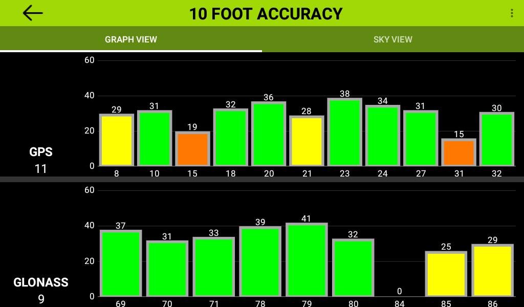
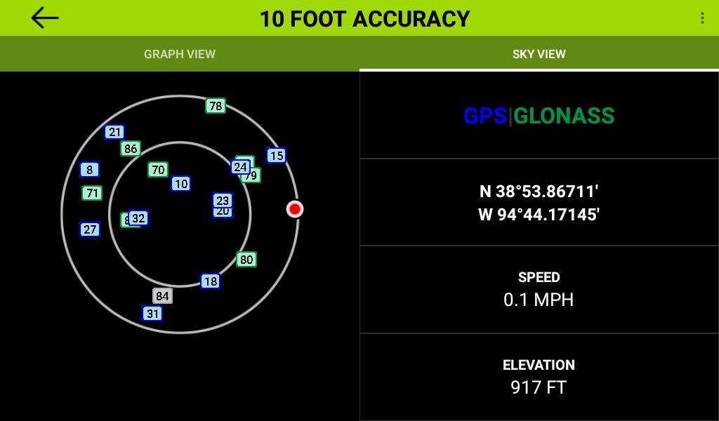
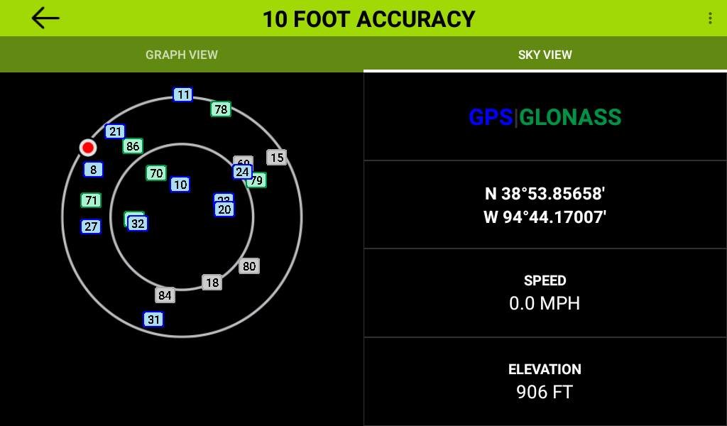
TL DR Se till att starta upp och ge GPS-mottagaren bra sikt mot himlen i mycket god tid innan du kör ut på banan. Optimizing GPS Performance Back in September we discussed the importance of GPS Orbital Data. I am going to make a deeper dive into this subject in an attempt to help our community optimize the performance of their Catalyst (or any other GPS based system). First, terminology and timing. Peter pointed us to a good summary. A mere 308 words, helpful animation, and definitions of GPS terms like TTFF, TTSF, Fix, Cold, Warm, Hot, Almanac, and most importantly Ephemeris. Please review it now at: https://en.wikipedia.org/wiki/Time_t Now, "It's NOT a Race!" Time To First or even Subsequent Fix does NOT matter for our application. We can get a 3D fix with ephemeris for only 4 satellites, but block line-of-sight visibility to any one of the 4 and we lose the fix. This post is about maintaining a fix, which requires ephemeris for, and line-of-sight to, at least 4 geospatially separated satellites at a time, while intermittently blocking visibility to various satellites due to turning corners on a road course. With ephemeris and distance measurements for more than 4 satellites, we can overdetermine the solution and achieve better accuracy. In general, the more geospatially separated satellites used, the better the accuracy. GPS satellites broadcast almanac for all GPS satellites, but each GPS satellite broadcasts ephemeris only for itself. We need a specific 22 seconds (available only every 30 seconds) of uninterrupted line-of-sight visibility to each satellite to download the required ephemeris. This is nearly impossible once we start driving and turning. Distance measurements for a satellite take only a fraction of a second, so once we have downloaded ephemeris, intermittently blocking visibility to a subset of the satellites is generally not a problem if we meet the requirements listed above. The key is to download ephemeris from as many satellites as possible before going on track. We can use the Catalyst Satellite Graph and Sky View pages to strategize and determine when ephemeris has been downloaded (see sample screen shots). Touch the signal bar icon at the top of the Home page or Start Track Session Checklist page to view Satellite pages. Swipe left and right to toggle between Satellite pages. Black filled signal strength bars indicate no ephemeris, color filled bars indicate ephemeris downloaded. Satellite ID Number is shown below the bars. The North-up Sky View maps where the satellites are relative to us. The outer circle represents the horizon, inner circle 45 degrees above, and center directly overhead. Gray filled satellite symbols indicate no ephemeris, blue (GPS) and green (GLONASS) filled satellite symbols indicate ephemeris downloaded. We can evaluate our surroundings to determine if we should reorient our vehicle and/or if it is worth waiting for ephemeris from specific satellites. Keep in mind high frequency satellite signals will not travel through metal, carbon fiber, or dense structures so we may not be able to get ephemeris for satellites too low on the horizon. GPS satellites orbit the Earth twice a day so between sessions, some will have set below the horizon, and new ones will have risen above the horizon. We must allow time to download ephemeris for any newly visible satellites before each session. Depending on the track environment, we may not have the flexibility or time to download ephemeris from inside our cars. We can always take the Catalyst tablet out of the car, walk out to the middle of the paddock, away from metallic or dense structures and download ephemeris. Maximizing the number of satellites with ephemeris downloaded before going on track will provide the highest probability of maintaining a fix with the best possible accuracy and optimize our GPS performance. 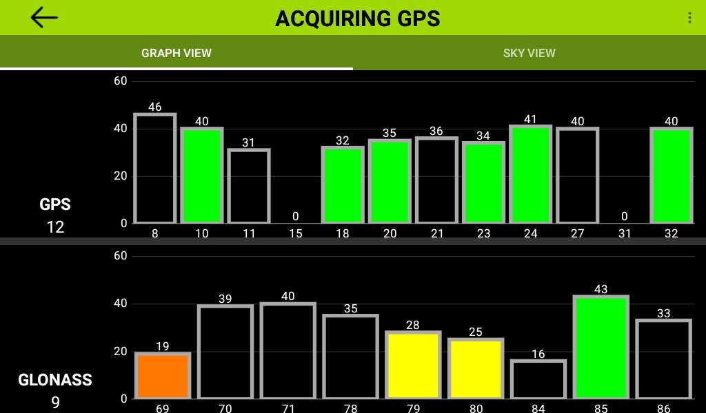
_________________  Magnus Thomé Magnus Thomé

|
|
Om hård- och mjukvara för loggning & video
Vikigt att veta om GPS inför bankörandet
|
574 besök totalt |


